Naujan
Leaving the airport and walking on the well-worn trail that follows the southern shoreline of Repulse Bay, the visitor will come upon the Naujan Thule Site. Allow lots of time, since it's a five kilometer trek.
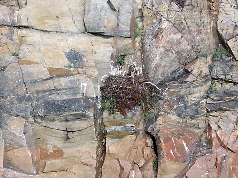
The Thule lived in large coastal communities, leaving each day for the sea to hunt whales. They used large skin boats.
The story of Naujan is a story inextricably linked with one expedition and in particular with one man. The expedition is that of the Fifth Thule Expedition of 1921-25 and the man is Therkel Mathiassen.
As Therkel Mathiassen himself stated, the discovery of the Naujan Site was the result of both circumstances and convenience. On the advice of the local Hudson Bay Company manager in Repulse Bay, Mathiassen and his colleague K. Birket-Smith visited a site, in December 1921,, where there remained the ruins of several permanent house structures. Both men were intrigued by the elevated location of the houses so far from the shore and by archaic nature of the implements founds at the site. They were also aware that the custom of building permanent stone houses was not one upheld by the current inhabitants of the area at the time, the Aivilingmiut. Spurred on by these observations and the proximity to a station at Repulse Bay from which artifacts could be transported home, the decision was made to return the following year to investigate.
In June of 1922, Mathiassen began excavation at the south end of Naujan Lake. This was the first scientific investigation of archaeological resources ever to be undertaken in the Canadian Arctic. The Fifth Thule Expedition, sponsored by the Danish government, represented a novel interdisciplinary approach to archaeological discoveries. It was Mathiassen's discovery of Naujan and his analysis of the find that was to make the greatest impact upon the prehistory of the Canadian Arctic with the definition of Thule culture.
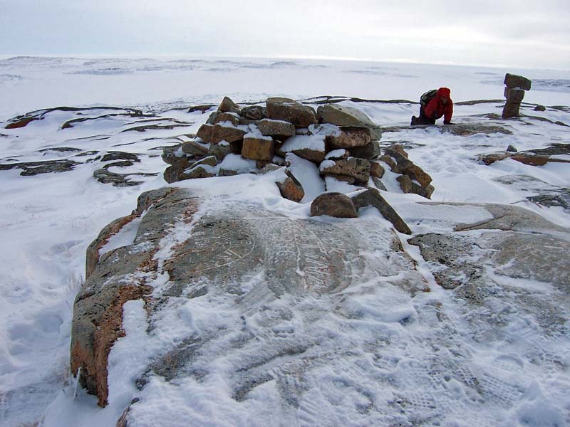
Despite slow progress due to the presence of permafrost, a total of 12 houses and 60 sq. meters of a refuse heap (1 meter deep) were excavated. In addition to excavation, the investigations included taking measurements of the ruins, photographing and mapping the area and nearby graves, and collecting over 3,000 specimens including two fairly complete skeletons and about 20 skulls.
In his excavations, Mathiassen found the house structures to be fairly uniform. They were circular, with a diameter of 4 to 5 meters, and were half under the ground. He called them of the 'whalebone' type because their walls were made of stones, sod, and whale skulls while the roofs were of whale jawbones and ribs and sod. The artifacts found in the midden and scattered about the area showed a similar reliance on whale products. Nets, bows, arrows, knives, and cups among other implements had been fashioned from the versatile whale baleen.
In his study of the site, Mathiassen noted the primitive style of the artifacts and the absence of any foreign (European) goods which lead him to believe that the site had been inhabited long ago and then abandoned. He also believed that the elevated location of the village site was a result not of choice but of a rapid rising of the land surface since their construction. The presence of numerous raised beaches also attested to this, indicating an uplift of up to 13 meters.
However, it was Mathiassen's synthesis of his finds at Naujan with the finds of other scientists along the Arctic Coast that gave the site its real significance. It was apparent from studies and excavations at a number of other sites along the coast, that remains similar to those found at Naujan yet very different from the existing Inuit culture could be found. Typically, they were located on land 8-13 meters above sea level, close to but not immediately on the shoreline, and displayed the characteristic circular, semi-subterranean, stone and whalebone houses and implements exhibiting a heavy reliance upon whale products. In contrast, the existing Inuit culture built winter houses out of snow and relied heavily upon land as opposed to sea mammals. It was the consistency in archaeological evidence that lead Mathiassen to identify the existence of a unique culture in Arctic prehistory prior to the present Inuit people. He named this culture the Thule culture, after the first discovery of a representative artifact in Comer's Midden near Thule, Greenland by the Second Thule Expedition. The village of Naujan then, as the second but most extensively excavated site, became the 'type site' of Thule culture.
Since the publication of the Expedition's reports in the mid 1920's, the discipline of Arctic archaeology has burgeoned. New finds have served to substantiate and expand on Mathiassen's findings and to piece together even earlier occupations of the Canadian Arctic. With the modern convenience of radiocarbon dating it has been possible to classify the occupation of the northwestern Hudson Bay coast in the following way:
| Pre-Dorset | 1500 B.C. – 800 B.C. |
| Dorset | 800 B.C. – A.D. 1000 |
| Classic Thule | A.D. 1000 – A.D. 1200 |
| Modified Thule | A.D. 1200 – A.D. 1610 |
| Historic Inuit | A.D. 1610 – present |
More recent studies propose that the relatively rapid expansion of Thule culture across the Arctic was the result of a climatic warming trend during the Neo-Atlantic period (around A.D. 1000). Such a warming trend served to open up the previously ice choked channels and enable the entrance or large whales into coastal areas. The development of a whaling technology then, encouraged the movement of a people with distinct technological differences eastward into Arctic Canada at a relatively rapid pace.
The 'Classic Thule' people were characterized by their circular stone houses described above and their heavy reliance on whaling as a livelihood. However, soon after their migration, the climate began to deteriorate and again ice blocked much of the coastline. Out of necessity, other sea mammals and caribou replaced whales as the primary source of food and resources and snow became the major construction material for winter dwellings. This period of about 400 years has been labelled the 'Modified Thule' period and is the predecessor of the Historic Inuit period. Unlike the hypothesized rapid migration of the Thule culture, there was a marked transition from Modified Thule to Historic Inuit identified by the intrusion of European goods and customs.
Thus, it is clear that Mathiassen's work at Naujan provided the foundation upon which the last 60 years of arctic archaeology has been based.
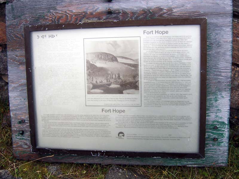
Fort Hope on the North Pole River (John Rae's Stonehouse)
The impetus behind exploration in the Canadian Arctic had its beginnings in the quest for a Northwest Passage enabling vessels to travel from Europe to the riches of the Orient. It was an endeavour that consumed men and wealth and one that would elude attempts for over 300 years. While its roots were purely commercial in nature, by the early-mid 1800's it had become a geographical curiosity and the race was on to solve the puzzle.
By 1846, the year Dr. John Rae embarked on his first arctic expedition, a great amount was known about the geography of the polar regions. Among the expeditions before him had been those of Edward Parry, George Back, Edward Sabine, John and James Clark Ross and John Franklin in 1818, Lyon (1825), Parry (1829 and 1833), John and James Clark Ross (1829-33), and Back (1836). There had also been overland expeditions by Franklin and John Richardson, Back, and Dease and Simpson. It was the last of these that was instrumental in the commissioning of Rae on his first arctic expedition.
At the time of Rae's departure there was only one portion of the Arctic's mainland coastline that remained uncharted: that part extending from just north of the Great Fish River estuary (the Castor and Pollux River) to Fury and Hecla Strait at the north end of the Melville Peninsula. It had been Dease and Simpson who had extended the charting as far east as the Castor and Pollux River in 1839 and Simpson who had proposed he command a further expedition to survey the final uncharted portion of the coast. However, Simpson's early death meant that the Hudson's Bay Company needed an able and energetic explorer to carry out the final charting proposed by Simpson and to solve a controversy that has developed over the Boothia Peninsula. From their observations, Dease and Simpson were convinced that Boothia Peninsula was in fact an island and that the Gulf of Boothia was connected directly to the Great Fish River Estuary. However, John and James Ross, in their Victory Expedition of 1829-33, were led to believe that a passage did not exist through the Boothia as it was a protrusion of the mainland. The solution to such a controversy had direct implications upon the possibility of a Northwest Passage.
Thus it was John Rae, a young doctor practicing in Canada at the time, who was commissioned in 1846 to sail up the west coast of Husdon Bay from Churchill to Repulse Bay to examine the north coast. Although far from a veteran explorer, Dr. Rae has established a reputation as being extremely practical and knowledgeable about life in the north as well as incredibly fit. As one colleague noted of Rae:
"He was very muscular and active, full of animal spirits, and had a fine intellectual countenance. He was considered, by those who knew him well, to be one of the best snowshoe walkers in the service, was an excellent rifle-shot and could stand an immense amount of fatigue…" (Mitchell 1936)
In June 1846, Rae set out from York Factory with ten men and two 22' boats. He arrived at Repulse Bay on July 25th and immediately set about crossing the isthmus to reach the north coast. He succeeded and named the bay on the other side Committee Bay but soon realized the futility in attempting any surveying of the ice choked coastline. Thus, Rae returned to Repulse Bay on August 10 and prepared to stay the winter.
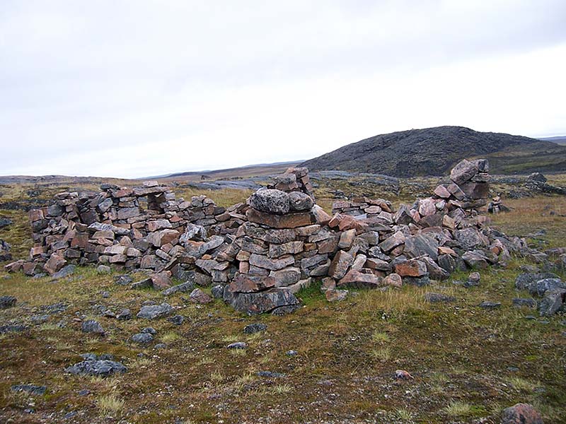
It was at this time that Rae and his men built the stonehouse at Fort Hope. He evidently had in mind to build a house of stone as he had carried with him four small double paned windows from Churchill. Rae was familiar with the construction of stonehouses from his native Scotland and the abundance of suitable sedimentary rock as well as lime rich clay from the river made it a logical choice at the time. Having begun construction on the 18th of August, the crew completed the 20 foot by 14 foot structure by the 2nd of September. It had a height of 7 ½ feet in the front sloping to 5 ½ feet at the back with a roof made from oars and masts of the boats covered by oilcloth and moose skin. The walls were 2 feet in thickness with openings for 3 small windows.

With construction finished and enough fuel gathered to last the winter, Rae and the crew were prepared for the long months ahead. After an unsuccessful attempt to organize a school for his crew, Rae settled down to a cold, damp, and dark winter. When he was not out hunting for meat to supply the larder, a skill which he continued to perfect, he was leafing through a copy of Shakespeare's plays by the flame of an Inuit-style lamp. When Christmas arrived Rae was said to have furnished his men with a grand feast of venison steak and plum pudding as well as enough brandy to make the group "merry and comfortable".
It is clear that Rae was a well loved and respected leader, one that took the utmost care of those in his command but in return demanded much of them physically. His ability to live from the land was no better illustrated by the fact that he had taken only enough supplies to last the expedition four months yet he stayed a total of fourteen months. Rae and his party were in fact, the first foreigners to keep themselves alive and capable of work by living exclusively from the resources the Arctic environment has to offer. It was Rae's proficiency as a hunter and fisherman that was largely responsible as he had shot almost as much game as all the other men put together.
Eager to begin his survey investigations Rae and five of his men left Fort Hope on April 5, 1847. They crossed the isthmus and headed west along the Committee Bay until they reached Lord Mayor's Bay, a point previously charted by James Clark Ross during the Victory Expedition. On his return Rae made a complete examination of the coastline all except Pelly Bay. Rae's decision to cut across the end of Pelly Bay instead of walking its entire length led to controversy on his return to England over the possible existence of a channel westwards from the end of Pelly Bay. However, Rae was satisfied that his investigations had indeed proved that Boothia was a peninsula and that no navigable channel existed that might contribute to a Northwest Passage. Rae and his men returned to Fort Hope on May 5th.
By the 13th of May, Rae was off again this time to chart the western coast of Melville Peninsula. In record time he and his men followed the coast to within eight miles of Fury and Hecla Strait, but had to turn back because of a shortage of food. After a difficult and demanding Journey, the group arrived back at Fort Hope on June 9th. Thus, Rae had accomplished his mission. He had charted over 650 miles of new coastline and joined Ross' Boothia discoveries with Parry's Melville Peninsula discoveries. He had also proved (except for the controversy over Pelly Bay) that Boothia was a peninsula and not as Dease and Simpson had implied, an island.
Rae and his men left Fort Hope and their stonehouse on August 12, 1847 with Rae returning to England in October of the same year. On his return Rae heard of a concern that would govern his life for the following seven years. Rae made three more expeditions into the Arctic all in search of evidence of the Franklin party. On the last one, in 1853-54, Rae wintered over once again in Repulse Bay. By this time however he had learned of the advantages of snow houses and chose one for his winter dwelling rather than spend another dreary season in the stonehouse which had remained in fairly good condition at Fort Hope. It was on this journey that Rae learned from the Inuit of the fate of Franklin's ships the 'Erebus' and the 'terror'.
The next visit to Fort Hope is recorded by Captain C.F. Hall who stayed in the region of Repulse Bay for four winters and visited the site of Fort Hope during the winter of 1865-66. He too had no intention of staying within such cold, gloomy walls and marvelled at Rae's ultimate success in such a dreadful environment.
"…one is impressed first by his great physical strength and remarkable powers of endurance. He walked 10,490 km during four expeditions, and he travelled another 10,700 km in small boats. He surveyed and mapped 2,825 km of previously unexplored territory, including 2,480 new km of northern coastline. He was intelligent, an accurate observer, a competent writer, and an accomplished doctor. He was pleasant, cheerful, generous, and sensitive. He was frugal, conducting his surveys more economically than anyone before or since. He was sympathetic to the natives and willing to learn their methods of travel, hunting, and building snow houses. And he was candidly honest to the point of forfeiting the knighthood he so richly deserved." (Houston, C.S. 1987)
Thus, the remains of the stonehouse at Fort Hope stand as a monument to a remarkable man, Dr. John Rae.
Ship Harbour Islands
The Ship Harbour Islands consist of approximately 15 islands lying off the north coast of Repulse Bay. A little over a kilometer from shore, the islands appear as sparsely vegetated rocky outcrops. The largest island, measuring approximately 2 km by 1 km, has two small creeks each fed by a lake.
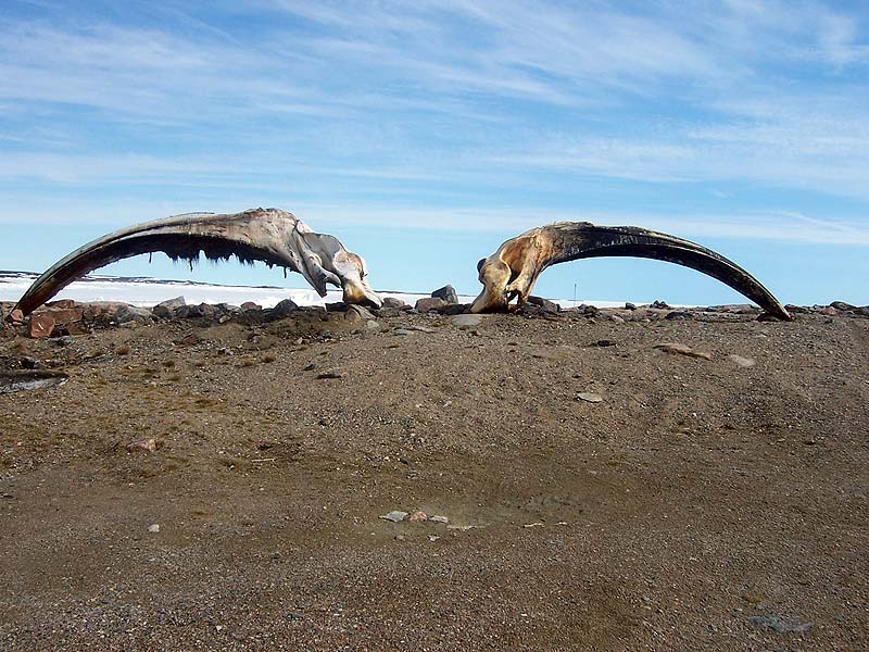
European and American whaling ships were drawn to the Canadian Arctic in the early 18th century by the lure of a prosperous whale fishery. Whale oil and baleen had become prized commodities in the industrializing world for use in lamps and ladies corsets amongst other things. The first and most prolific whaling ground to be exploited was the Davis Strait and Cumberland Sound area beginning in the early 18th century. However, by the mid 19th century with an ever-increasing demand for whale products and with depleted whale stocks in the Davis Strait region, whalers ventured further inland to Hudson Bay. Although the fishery here had only a fraction of the potential of the Davis Strait fishery, the abundance of whales particularly along the northwestern coast provided the basis for the following 50 years of the whale fishery. By 1915 whale stocks were depleted, substitutes for both whale oil and baleen were in existence and the efforts of foreign entrepreneurs had turned towards the more lucrative fur trade.
The extension of whaling activities into the relatively remote northwestern Hudson Bay region from the more accessible Davis Strait area had implications upon the industry. The practice of whalers "wintering over" in the Bay in order to take advantage of two seasons of whaling before embarking on the long journey back to home port, had begun. Whaling vessels, primarily of British and American origin, would arrive in Hudson Bay as soon as the ice would allow, usually by mid-summer. They would spend the last weeks of summer, while the waters were free of ice, cruising up and down the coast in search of bowhead whales. By the end of September whaling activities came to an end and the long months of winter lay ahead. Then, sometime near the end of April or beginning of May the whaleboats would be lowered onto the ice and hauled to the floe edge where spring whaling could take place. Once the harbour ice broke up sufficiently to free the whaling vessels themselves, the whalers again cruised the waters before heading home in autumn.
It was this practice of "wintering over" that lead to a new dimension of Arctic Whaling: the involvement of and impact upon the native Inuit people. Whaling captains were eager to procure assistance from the local Inuit in a number of ways. Most importantly, the Inuit were experienced hunters and could provide fresh meat during the long cold winters when threat of scurvy was very real. It was also essential that the crew be warmly dressed in preparation for the chilling winter temperatures of the Arctic. The Inuit women were often commissioned by the foreigners to make winter clothing similar to their own for the crew. Finally, the value of the Inuit as able whalesmen to man additional whaling boats was soon recognized. As payment for their services, the Inuit were offered items such as guns, whaleboats, utensils, telescopes and other implements fashioned, in many cases, from material foreign to them.
Naturally, the native Inuit were eager to exchange their skills for what must have seemed to them 'miracle' tools. They soon gathered at points along the northwestern coast and Roe's Welcome Sound where the whalers often stopped or wintered over, places such as Marble Island, Depot Island, Cape Fullerton, and Repulse Bay. The traditionally nomadic settlement patterns of the Inuit soon responded to the demands of the foreigners and groups of up to 200 Inuit congregated at the whaling harbours. The lure of employment attracted Inuit from surrounding areas to the whaling grounds of Roe's Welcome Sound resulting in a curious mixing of Inuit regional cultures. Although traditionally the Sound area had been the territory of the local Aivilingmiut, they were joined by Netsilingmiut from King William Land, by Iglulingmiut from the Melville Peninsula and Kinipetu from Chesterfield Inlet. Many of them would take up residence close to the harbour as their services were needed virtually year-round. Here they could easily respond to the needs of the whalesmen and they could also enjoy the many social activities offered during the long winter months. Dances, plays, concerts, and sport activities were equally enjoyed by sailors and Inuit alike.
By the time the whaling industry was plying the waters of northwestern Hudson Bay the depletion of whale stocks has caused the industry to become far more competitive than in its earlier days. The whaling captains, recognizing the crucial role that the Inuit had to play in the profitability of their trips, were careful to maintain good relations. Strong ties sometimes developed between particular captains and a group of Inuit to the point that upon leaving the whaling grounds at the end of a season the captain would commission the Inuit to undertake spring whaling for the whaler until its return later next season.
This year round and extended contact with the whalers in the Bay had a more far reaching impact than the previous two hundred years when contact with explorers looking for the Northwest Passage had been infrequent and only lasted for short periods of time. By the time whaling drew to a close in 1915, the life of the Inuit along the northeast coast of Hudson Bay had been greatly altered by this prolonged contact which resulted in the incorporation of many aspects of the Euro-American culture. Repulse Bay, the northernmost wintering point along Roe's Welcome Sound, was one such node of acculturation. The local Aivillingmiut were one of the primary groups of Inuit employed in the northwest Hudson Bay whale fishery.
Two published accounts in particular, offer an indication of the whaling activity in Repulse Bay and its significance as one of the locations where Inuit would congregate to establish trade and seek employment. The first relates the voyages of the Hudson Bay Company's whaler the 'Perseverance' which wintered in Repulse Bay in both the 1892-3 and the 1896-7 seasons. During the latter season the 'Perseverance ' was joined by the 'Platina' from New Bedford, Massachusetts and as Ross relates, the Bay was bustling:
"The winter community at the Ship Harbour Islands in Repulse Bay was large and multiracial. When the Platina gave a Christmas dinner and dance, 200 Inuit were present, from at least three distinct groups or subcultures. The crews of the two whalers numbered about thirty-five and included men of diverse nationalities and origins. Socially and economically Inuit and whalemen had developed a symbiotic relationship that transcended the boundaries or region or race." (Ross, 1973)
The second account, the published journal of Captain George Comer, makes frequent reference to whaling activities in and around Repulse Bay. Although Comer did not winter in Repulse Bay, preferring instead Cape Fullerton and Depot Island, he did gather astute ethnographical information on the Aivillingmiut of the area. In his introduction to the journal W.G. Ross identifies Repulse Bay as an anchorage, in keeping with Depot Island and Cape Fullerton, which "attracted wintering vessels from time to time, and provided occasional protection in summer to ships cruising for whales" (Ross 1984). He also notes the presence of a small Scottish vessel, the 'Ernest William' which "spent several years in Repulse Bay and Lyon Inlet after 1903, functioning as a whaling station and trading post."